CHC Navigation offers advanced GPS/GNSS machine control systems for excavators, dozers, graders, and compactors. Improve accuracy, cut costs, and complete construction projects faster with reliable global support.
We offer tractor guidance and auto-steering systems for farms of any size, powered by GPS farming technologies. Improve your precision agriculture practices with smart agriculture solutions starting today.
How to Start with GPS Farming: A Step-by-Step Guide
2025-11-13
How to Start with GPS Farming: A Step-by-Step Guide
Agriculture has entered a new era of intelligence and efficiency. GPS farming, also known as precision agriculture, is transforming how farmers plan, plant, and harvest crops. By combining satellite-based navigation, real-time data, and automated control systems, GPS farming enables farmers to achieve centimeter-level accuracy, minimize waste, and make every pass count.
If you’re wondering how to begin, the process is simpler than it seems. Whether you’re managing a small family farm or a large-scale operation, the key is to start with the right technology and expand step by step. In this guide, we’ll explore how to start GPS farming effectively, featuring innovative solutions from CHCNAV — a global leader in precision agriculture technology.
Step 1: Assess and Prepare Your Farm
Before investing in equipment, take time to evaluate your field conditions. Uneven terrain, poor drainage, or inconsistent irrigation can reduce yields and complicate GPS-based operations. Proper land preparation ensures your precision systems perform at their best.
This is where the CHCNAV IC100 Land-Levelling System shines. It combines GNSS RTK technology with electro-hydraulic control to automatically adjust your scraper or blade for perfect leveling. Delivering ±2 cm accuracy, the IC100 creates an ideal field surface that improves water management, enhances crop uniformity, and reduces erosion.
By leveling your land before planting, you build a solid foundation for GPS-guided precision farming — ensuring every future pass is smoother and more efficient.
Step 2: Start Simple with Manual Guidance
Transitioning into GPS farming doesn’t mean you need to automate everything immediately. For beginners, manual guidance systems offer a cost-effective and user-friendly entry point. These systems help operators maintain straight, consistent passes, reducing overlap and minimizing wasted fuel and fertilizer.
The CHCNAV Guide 10 Manual Guidance System is designed specifically for this stage. Featuring a bright 10.1-inch touchscreen, durable IP65-rated housing, and an intuitive interface, it provides clear, real-time guidance to keep your tractor on track. The integrated IMU sensor delivers terrain compensation, maintaining accuracy on slopes or uneven fields.
With multiple guidance modes — AB line, A+ line, curve, and circular patterns — the Guide 10 adapts easily to ploughing, spraying, or seeding operations.
Starting with the Guide 10 allows you to immediately experience the benefits of GPS farming: straighter lines, lower fuel costs, and higher productivity — while preparing for future upgrades.
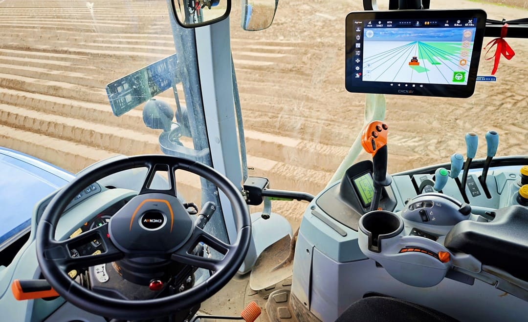
Step 3: Upgrade to Auto-Steering
Once you’re comfortable with GPS guidance, it’s time to automate. An auto-steering system takes control of the steering wheel, allowing you to focus on implement operation and field performance rather than manual driving.
The CHCNAV Auto-Steering Systems bring hands-free precision to both new and existing tractors. Offering up to 2.5 cm pass-to-pass accuracy, they combine GNSS and INS (Inertial Navigation System) technology for stable, precise steering. With support for multiple satellite constellations, 4G, UHF, and Wi-Fi connectivity, they provide reliable positioning in real-world farming conditions.
For farmers who demand advanced performance, systems such as the NX612 offer enhanced connectivity, improved terrain compensation, and expanded compatibility across many types of machinery.
Simple to install and compatible with a wide range of tractors, CHCNAV’s auto-steering systems reduce operator fatigue, improve coverage, and increase overall field efficiency. Whether planting, spraying, or harvesting, auto-steering ensures consistency, saves time, and lets you work longer with less stress.
The CHCNAV NX612 Automated Steering System, installed in the tractor, delivers ±2.5 cm GNSS RTK accuracy, reliable performance in diverse farming conditions, and simple operation through a compact design and 12-inch HD display.
Step 4: Monitor, Analyze, and Optimize
Once your GPS farming systems are running, the next step is optimization. Modern guidance and steering systems like the Guide 10, NX610, and NX612 automatically log detailed field data, helping you analyze performance over time. You can review coverage maps, identify missed areas, and plan more efficient routes for future operations.
As your confidence grows, expand your precision farming setup with advanced capabilities like variable-rate seeding, automated spraying, or yield mapping. Because CHCNAV’s systems are modular and scalable, you can easily upgrade components without replacing the entire system — protecting your investment and ensuring future readiness.
Why Choose CHCNAV for GPS Farming
For over two decades, CHCNAV has been a global leader in precision positioning and navigation technology. Their agricultural solutions combine accuracy, reliability, and ease of use — empowering farmers of all sizes to adopt GPS farming confidently.
From the IC100 Land-Levelling System for field preparation, to the Guide 10 Manual Guidance System for beginners, and the NX610 / NX612 Auto-Steering Systems for advanced automation, CHCNAV provides a complete ecosystem that supports every stage of your precision agriculture journey.
By starting small and upgrading step by step, you can achieve measurable gains in efficiency, productivity, and sustainability — all backed by CHCNAV’s proven technology and worldwide support network.
Final Thoughts
Starting with GPS farming isn’t just about adopting new technology — it’s about transforming the way you farm. From leveling your land and improving accuracy to automating your equipment, each step brings you closer to a smarter, more sustainable operation.
With CHCNAV’s precision agriculture solutions, farmers can take control of their productivity and make data-driven decisions with confidence. Whether you start with the Guide 10, enhance efficiency with the NX610 or NX612, or achieve full automation with the IC100 Land-Levelling System, you’re setting your farm up for long-term success.
____
About CHC Navigation
CHC Navigation (CHCNAV) develops advanced mapping, navigation and positioning solutions designed to increase productivity and efficiency. Serving industries such as geospatial, agriculture, construction and autonomy, CHCNAV delivers innovative technologies that empower professionals and drive industry advancement. With a global presence spanning over 140 countries and a team of more than 2,000 professionals, CHC Navigation is recognized as a leader in the geospatial industry and beyond. For more information about CHC Navigation [Huace:300627.SZ], please visit: https://www.chcnav.com/about/overview
Have a question about our solutions or dealership opportunities?