CHC Navigation offers advanced GPS/GNSS machine control systems for excavators, dozers, graders, and compactors. Improve accuracy, cut costs, and complete construction projects faster with reliable global support.
CHC Navigation Introduces HN-400M MBES for High-Resolution Bathymetric Surveying
2026-06-17
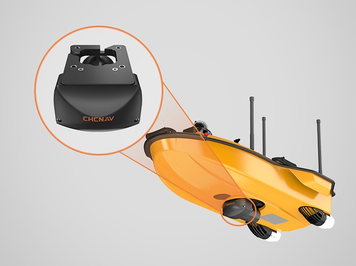
Shanghai, China – June 17, 2026 – CHC Navigation (CHCNAV), a technology provider of geospatial solutions, announced the release of the CHCNAV HN-400M, a compact multibeam echosounder designed for bathymetric surveying in conditions where turbidity, changing depth, vessel motion, and platform size can affect data acquisition. Developed for both unmanned surface vessels (USVs) and manned survey platforms, the HN-400M combines adjustable 400 to 550 kHz sonar operation, integrated INS motion compensation, and a compact, calibration-free design to support efficient underwater topographic mapping in rivers, lakes, reservoirs, channels, ports, and nearshore areas.
HN-400M multibeam echosounder installed on CHCNAV APACHE 4 USV for bathymetric surveying operations.
Dual-frequency multibeam echosounder for flexible hydrographic surveys
The HN-400M operates with an adjustable 400 to 550 kHz frequency, giving hydrographic survey teams the flexibility to adapt to different water conditions and project requirements. The 550 kHz frequency supports high-resolution shallow-water bathymetry, while the 400 kHz frequency supports broader survey use in deeper or more turbid environments. The dual-frequency multibeam sonar configuration enables a wide range of hydrographic survey tasks with a single system, from river and lake mapping to reservoir surveys, port engineering, channel maintenance, and nearshore bathymetric data collection.
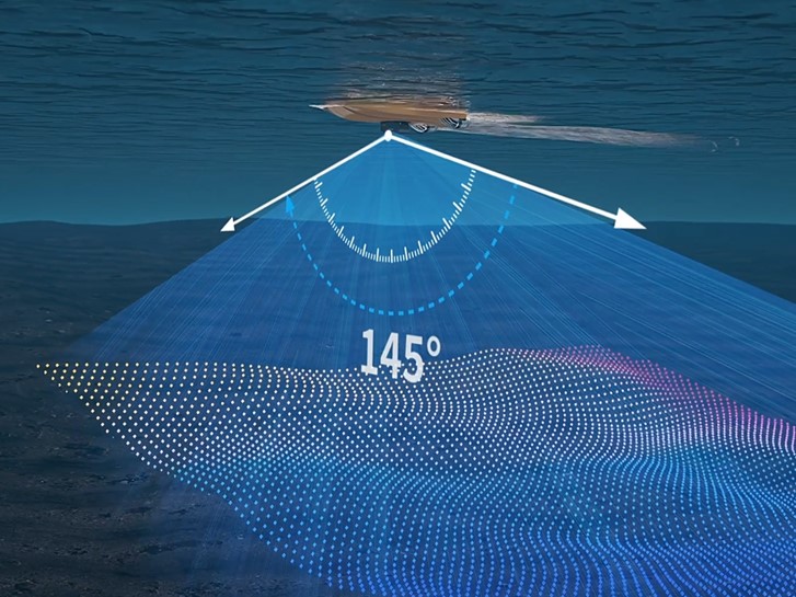
Wide swath coverage for efficient bathymetric mapping
The HN-400M provides up to 145 degrees of swath coverage and supports coverage widths of up to six times the water depth. With 512 receive beams, a measurement range from 0.2 m to 200 m, and range resolution of less than 10 mm, the system is designed to capture dense bathymetric data efficiently. Its wide swath capability helps survey teams reduce line spacing, improve coverage efficiency, and collect detailed underwater topographic data for engineering, inspection, dredging, and environmental monitoring applications.
Integrated INS motion compensation for stable data acquisition
Survey vessels often operate in conditions where pitch, roll, and heave can affect bathymetric data quality. The HN-400M integrates INS-based motion compensation with 0.03-degree pitch and roll accuracy. The integrated motion compensation maintains data stability during vessel movement and supports consistent hydrographic survey results in changing water conditions.
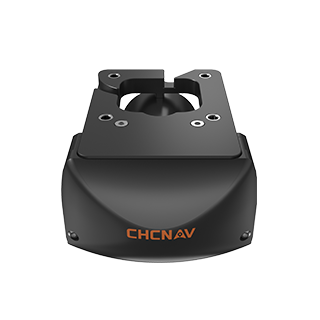
Compact MBES design for USVs and manned vessels
With a compact sonar head and a total weight of 3.5 kg with bracket, the HN-400M is designed for rapid field deployment on both USVs and manned survey boats. Its calibration-free installation reduces setup time and simplifies mobilization for teams working across multiple survey sites. The system is suitable for hydrographic professionals who need a portable multibeam echosounder for compact survey platforms, small boats, and unmanned surface vessel operations.
Software compatibility for complete hydrographic workflows
The HN-400M supports CHCNAV EasySail for Android-based field control and acquisition, as well as CHCNAV CMS and CoSail for post-processing. It is also compatible with widely used hydrographic software platforms, including Beamworx, HYPACK, QPS, EIVA, and CARIS. Its software compatibility allows survey teams to integrate the HN-400M into established hydrographic data acquisition, processing, analysis, and reporting workflows with minimal disruption.
____
About CHC Navigation
CHC Navigation (CHCNAV) develops advanced mapping, navigation, and positioning solutions designed to increase productivity and efficiency. Serving industries such as geospatial, agriculture, machine control and autonomy, CHCNAV delivers innovative technologies that empower professionals and drive industry advancement. With a global presence spanning over 140 countries and a team of more than 2,200 professionals, CHC Navigation is recognized as a leader in the geospatial industry and beyond. For more information about CHC Navigation [Huace:300627.SZ], please visit: https://www.chcnav.com/about/overview