CHC Navigation delivers precision geospatial solutions with advanced mapping systems, unmanned platforms, and GNSS+INS+LiDAR technology for spatial data capture.
CHC Navigation offers advanced GPS/GNSS machine control systems for excavators, dozers, graders, and compactors. Improve accuracy, cut costs, and complete construction projects faster with reliable global support.
CHC Navigation delivers high-precision GNSS + INS navigation systems for autonomous vehicle, automotive, robotics, mining, marine, and industrial applications.
We offer tractor guidance and auto-steering systems for farms of any size, powered by GPS farming technologies. Improve your precision agriculture practices with smart agriculture solutions starting today.
CHC Navigation Launches AlphaAir 6, a Long-Range Airborne LiDAR System for UAV Mapping and Aerial Surveying
2026-04-09
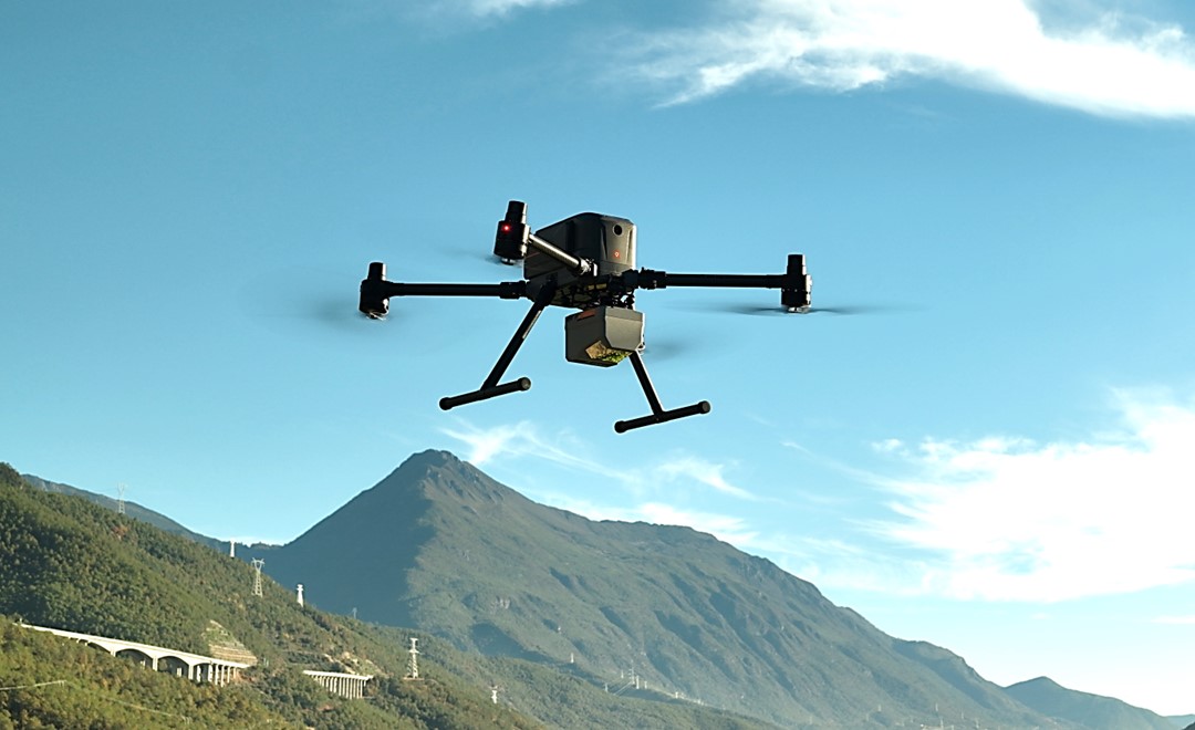
Shanghai, China - April 9, 2026 - CHC Navigation (CHCNAV), a global technology leader in mapping, navigation, and positioning solutions, today announced the AlphaAir 6 (AA6), a flagship airborne LiDAR system designed for UAV-based laser scanning, drone LiDAR mapping, and aerial surveying in high-relief and complex terrain. Combining prism scanning technology with a high-grade inertial navigation system, the AA6 delivers a maximum ranging capability of up to 2,100 m and supports efficient data capture at typical flight altitudes of 400 to 600 m above ground level.
AlphaAir 6 is mounted on the X500 UAV during an urban mapping mission.
Long-Range Performance for Demanding Survey Missions
The AA6 integrates an upgraded laser engine and a high-grade IMU with 0.3°/h bias stability to improve trajectory accuracy and point cloud quality. This design removes the need for pre-mission IMU calibration and supports stable, efficient data collection for topographic mapping, corridor mapping, and wide-area aerial survey workflows.
Higher Point Density with Real-Time Waveform Processing
The AlphaAir 6 combines 5th-generation real-time waveform processing with advanced multi-period technology to capture richer, denser, and more precise LiDAR data across complex terrain, vegetation, and built environments. Even at an ultra-high pulse repetition rate of 2,000,000 pulses per second, it continues to support real-time point cloud output, giving operators immediate in-flight visibility and a faster path to survey-grade 3D results.
Flexible Imaging for Aerial Mapping Projects
To meet different project requirements, the AA6 is available in single-camera and dual-camera configurations. Both options use large-format CMOS sensors to deliver high-resolution imagery, while the dual-camera version adds an ultra-wide field of view to improve image coverage and increase mapping efficiency.
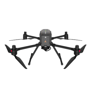
Lightweight Design and Broad UAV Compatibility
With an integrated design and a weight of just 1.35 kg, the AA6 reduces payload burden on UAV platforms and helps extend flight endurance. Open interface protocols support integration with mainstream multirotor and fixed-wing UAVs, giving surveying and mapping professionals more flexibility across different mission types.
____
About CHC Navigation
CHC Navigation (CHCNAV) develops advanced mapping, navigation, and positioning solutions designed to increase productivity and efficiency. Serving industries such as geospatial, agriculture, machine control and autonomy, CHCNAV delivers innovative technologies that empower professionals and drive industry advancement. With a global presence spanning over 140 countries and a team of more than 2,200 professionals, CHC Navigation is recognized as a leader in the geospatial industry and beyond. For more information about CHC Navigation [Huace:300627.SZ], please visit: https://www.chcnav.com/about/overview