CHC Navigation offers advanced GPS/GNSS machine control systems for excavators, dozers, graders, and compactors. Improve accuracy, cut costs, and complete construction projects faster with reliable global support.
In construction and earthmoving, efficiency and precision drive every project outcome. Machine control systems are reshaping how contractors approach excavation, grading, and finished surfaces, replacing manual stakeout and repeated checks with real-time positioning data fed straight to the operator. As a global leader in GNSS positioning, CHC Navigation is building the products that make this transition practical for sites of every size.
What Machine Control Replaces
Traditional earthmoving leans on manual measurements and staking, a workflow prone to human error and slow on large or complex sites. Repeated checks inflate timelines, and operator fatigue compounds mistakes during long earthmoving days. Machine control replaces those steps with high-precision positioning, sensor integration, and design-file driven guidance, so operators move from "measure and re-measure" to "follow the plan and verify results on site."
The Productivity Wins Across the Site
Precision in every pass. Live cut-and-fill data and equipment status updates ensure tasks are completed accurately the first time. Less rework, faster delivery.
Lower labour and material cost. Reduced dependence on surveyors and stakeout crews, plus cleaner cuts that lower fuel burn and equipment wear.
Adaptive to design change. Updated design files load directly to the in-cab controller; operators absorb late-stage changes without halting the workflow.
Centimetre accuracy in tough conditions. Tightly coupled GNSS and INS keep the line accurate on uneven terrain, near tall structures, or in obstructed environments.
One Portfolio for Excavators, Dozers, and Graders
CHC Navigation's machine control portfolio is designed around the three workhorse machines on most earthmoving sites:
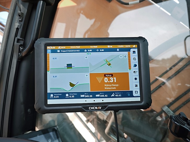
TX73 is a 3D excavator guidance system with high-frequency IMU sensors and dual GNSS receivers, delivering ±3 cm bucket-tip accuracy. It supports tilt and rotating buckets, accepts CAD design files directly, and typically installs and calibrates in around two hours.
TD63 Pro is an automatic 3D bulldozer control system with dual GNSS positioning and IMU sensing for precise blade control regardless of machine orientation. Real-time blade automation reaches finished-grade accuracy without manual staking, making it especially valuable for less experienced operators.
TG63 is a 3D grader control system tuned for fine grading. Dual GNSS plus inertial sensors driven by GR-Tech deliver continuous blade adjustments that follow the design surface, helping crews reach final grade faster.
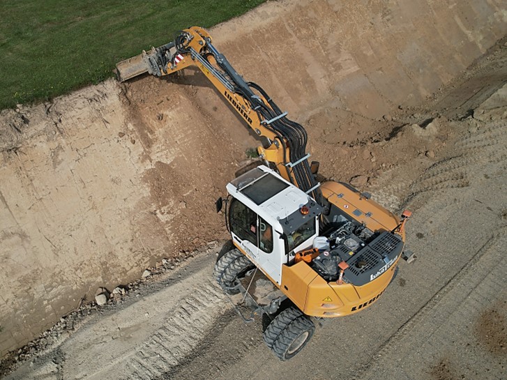
Excavator with TX73 machine control system shaping a road slope in Poland.
Machine Control That Scales Down to Small Crews
Machine control was once the preserve of large contractors. The EasyNAV EMG100 3D Excavator System is built specifically for small or independent operators, delivering centimetre accuracy at a cost-effective price. Setup and calibration finish in around two hours, the learning curve is roughly thirty minutes, and the system is compatible with a wide range of excavator models and attachments. Typical applications include small construction projects, agricultural land levelling, and trench excavation. The EasyNav Series gives smaller crews a clear entry point into digital construction without committing to enterprise-grade tooling.
From Survey to Site, Without Re-keying
Because CHC Navigation's machine control systems share the same GNSS and INS technology stack as our surveying solutions, data flows from collection to field execution without re-keying. CAD files come straight into the controller, base stations and RTK rovers handle stakeout and on-site verification, and on-site earthwork volume calculation runs through several methods including two-phase, reference elevation, reference point, and slope-based. Whether the site is a small grading job or a large infrastructure build, the same workflow holds together end to end.
____
About CHC Navigation
CHC Navigation (CHCNAV) develops advanced mapping, navigation, and positioning solutions designed to increase productivity and efficiency. Serving industries such as geospatial, agriculture, machine control and autonomy, CHCNAV delivers innovative technologies that empower professionals and drive industry advancement. With a global presence spanning over 140 countries and a team of more than 2,200 professionals, CHC Navigation is recognized as a leader in the geospatial industry and beyond. For more information about CHC Navigation [Huace:300627.SZ], please visit: https://www.chcnav.com/about/overview
Find the Right Machine Control Solution
Looking to improve accuracy and efficiency on your site? Get expert guidance on selecting the right machine control system for your equipment and projects.