CHC Navigation delivers precision geospatial solutions with advanced mapping systems, unmanned platforms, and GNSS+INS+LiDAR technology for spatial data capture.
CHC Navigation offers advanced GPS/GNSS machine control systems for excavators, dozers, graders, and compactors. Improve accuracy, cut costs, and complete construction projects faster with reliable global support.
CHC Navigation delivers high-precision GNSS + INS navigation systems for autonomous vehicle, automotive, robotics, mining, marine, and industrial applications.
We offer tractor guidance and auto-steering systems for farms of any size, powered by GPS farming technologies. Improve your precision agriculture practices with smart agriculture solutions starting today.
For most surveying professionals working with GNSS receivers in the field, the real challenge is no longer whether a receiver can deliver high precision under ideal conditions. It is whether that precision can be maintained when conditions change: when mobile coverage drops, when satellite visibility is restricted, when projects extend across long corridors, or when downtime in the field cascades into delays across the whole job.
That shift is changing how value is measured across surveying, mapping, construction, mining, and marine operations. Robustness, continuity, and operational resilience in GNSS surveying workflows now sit alongside accuracy at the top of the buyer's checklist. CHC Navigation's latest update to the CHCNAV i93, i85, i76, and iBase (announced March 31, 2026) is built around exactly this principle: strengthening the entire positioning workflow, from the chip up.
The new chip and satellite correction service were introduced by CHC Navigation at the 2026 CHCNAV Global Partner Conference, where dealers, surveying professionals, and integrators worldwide saw the platform presented in a single coordinated upgrade across the receiver, the correction layer, and the base station, each engineered to remove specific points of friction that limit fieldwork today.
Launching the StellaX and PointX Positioning Solutions at the 2026 CHCNAV Global Partner Conference.
Three Layers of Resilience
CHCNAV StellaX GNSS chip in the updated i93, i85, and i76 receivers strengthens multi-frequency signal tracking and anti-interference performance. The result is more stable RTK operation in urban canyons, vegetation, and other constrained environments where signal quality typically deteriorates.
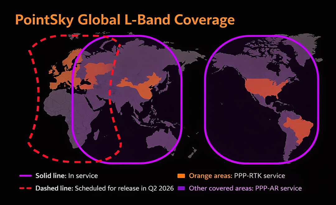
CHCNAV PointSky is now bundled as a standard one-year satellite RTK correction service on the i93 and i85, subject to regional availability. By delivering corrections via satellite, PointSky reduces reliance on local base stations and NTRIP, enabling centimeter-level positioning in areas where terrestrial infrastructure is unavailable or unreliable.
Upgraded iBase integrates DistLink technology and improved data compression to enhance radio sensitivity, extend working range for linear and corridor projects, and support more than 13 hours of operation without external batteries. One-button startup and automatic rover pairing simplify deployment in the field.
Global coverage map of the CHCNAV PointX satellite correction service.
Why It Matters: A More Resilient Workflow
What makes the update meaningful is how the three layers work together. StellaX strengthens performance at the signal level. PointSky expands access to high-precision positioning beyond the reach of mobile networks or routine base-station deployment. The upgraded iBase reinforces local radio operations for projects that still depend on strong base-rover communication, including corridor surveying and construction stakeout.
In demanding field operations, productivity rarely depends on one specification alone. It depends on how the full positioning solution holds up across changing environments, correction paths, and job demands. The strongest GNSS surveying workflows are not simply the most accurate. They are the most dependable.
For surveying teams, the practical takeaway is wider operational reach with fewer setup constraints. Topographic and cadastral crews benefit from cleaner fixes in obstructed environments. Linear projects across road, rail, and pipeline corridors gain longer base-rover working range without dropping the radio link. Marine, mining, and utility teams operating beyond cellular coverage can keep collecting centimeter-level data through the satellite correction path. The upgrade does not replace any one workflow. It widens the set of conditions under which a single GNSS toolkit continues to deliver consistent, project-grade accuracy.
CHC Navigation (CHCNAV) develops advanced mapping, navigation, and positioning solutions designed to increase productivity and efficiency. Serving industries such as geospatial, agriculture, machine control and autonomy, CHCNAV delivers innovative technologies that empower professionals and drive industry advancement. With a global presence spanning over 140 countries and a team of more than 2,200 professionals, CHC Navigation is recognized as a leader in the geospatial industry and beyond. For more information about CHC Navigation [Huace:300627.SZ], please visit: https://www.chcnav.com/about/overview
Have a question about our solutions or dealership opportunities?