CHC Navigation offers advanced GPS/GNSS machine control systems for excavators, dozers, graders, and compactors. Improve accuracy, cut costs, and complete construction projects faster with reliable global support.
We offer tractor guidance and auto-steering systems for farms of any size, powered by GPS farming technologies. Improve your precision agriculture practices with smart agriculture solutions starting today.
What Is Reality Capture? From 3D Scanning to 3D Reality Capture
2025-11-10
What is reality capture?
It’s the end-to-end process of turning the physical world into reliable digital assets. A reality-capture workflow blends sensors (LiDAR, cameras, IMU, GNSS) and software steps (alignment, georeferencing, QA/QC) to output measurable content - point clouds, meshes, orthos, BIM updates, and digital twins. 3D scanning is one technique inside that workflow: it directly measures geometry (usually via laser). 3D reality capture emphasizes three-dimensional, georeferenced results ready for CAD/BIM/GIS and field decisions.
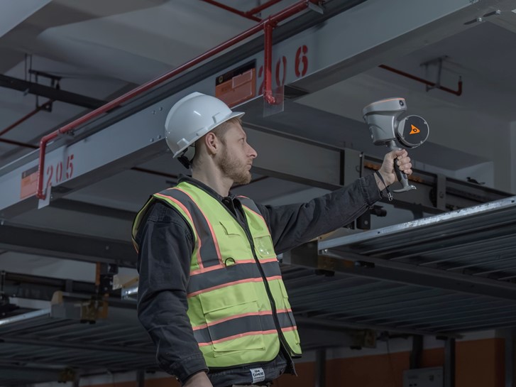
A current, field-proven example is CHC Navigation’s RS10, a handheld system that fuses GNSS RTK + LiDAR + visual SLAM to produce real-time georeferenced point clouds as you walk - indoors and outdoors. In other words, it joins fast 3D scanning with the full discipline of 3D reality capture, so teams leave site with usable, located data instead of “scan now, hope later.”
Why the RS10 matters for reality capture
Traditional tripod scanners deliver exquisite millimetric detail but can be slow over large, complex sites. The RS10 scanner addresses that gap by tightly fusing RTK positioning with LiDAR-SLAM, giving field crews centimeter-class results and instant feedback.
With an efficient loop-free workflow, the RS10 eliminates the need for traditional loop closure by integrating GNSS and SLAM technologies, simplifying field data collection and reducing project completion time and effort.
CHCNAV specifies ~5 cm absolute and ~1 cm relative accuracy, with live, georeferenced point clouds on the controller - so you can see coverage in real time and fix gaps before you pack up. Large areas up to ~13,000 m² can be mapped on site.
This indoor↔outdoor continuity is a big deal for facilities, campuses, mixed construction, utilities, and tunnels. Outdoor RTK provides absolute coordinates; when you step inside, SLAM carries the trajectory while staying in the same project coordinate system, avoiding messy re-georeferencing later. For weak/no-GNSS zones (urban canyons, basements), the RS10 can still compute accurate RTK point coordinates - useful when you must place scans in the right spot even without satellites.
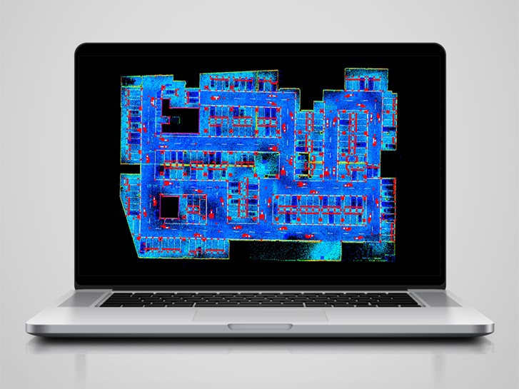
Left: Surveyor collects data in an underground parking garage using a CHCNAV RS10. Right: Survey data is processed and visualized in CoProcess software.
Key specs that speak to 3D scanning performance
For searchers comparing handheld systems, these RS10 specs are the essentials:
LiDAR options: 16-line or 32-line
Range: 120 m or 300 m
Scan rate: 320k or 640k pulses/s
FOV: about 210° × 170° (up to 2 returns)
Imaging: 3 × 5 MP cameras (15 MP total)
Accuracy: < 5 cm absolute (H/V), < 1 cm relative
Ruggedness: IP64
Power: hot-swappable batteries, ~60 min per pack
Mounting flexibility also matters in fast-paced jobs: the RS10 can be handheld, chest-mounted, pole-mounted, or vehicle-mounted, so one system adapts to corridors, plant rooms, long exteriors, or linear assets without a re-rig.
From 3D scanning to complete 3D reality capture
The difference between 3D scanning and 3D reality capture is what happens before and after the laser hits the scene. The RS10 illustrates the modern approach:
Plan the path, coordinate system, and control.
Capture with fused GNSS+SLAM so every pass contributes to a consistent trajectory.
See results in real time - a georeferenced point cloud appears as you go, enabling on-the-spot QA (did you get the stair core? that pipe manifold?).
Deliver clean point clouds/sections/meshes into CAD/BIM and GIS, with the right coordinates from the start.
That real-time georeferencing is the inflection point. Instead of discovering missing coverage or drift back at the office, teams correct in minutes while still on site - vital for shutdown windows, access-restricted areas, and field costs. CHCNAV RS10 supports loop-free operation, so you’re not forced to revisit the same locations to close trajectories - handy in congested or hazardous spaces.
Where it shines
As-built & BIM updates: Rapid walks of interiors, façades, plant rooms, and corridors; extract sections or compare against design the same day.
Utilities & linear infrastructure: Map substations, galleries, and rights-of-way without tripod hops; vehicle/pole mounts accelerate larger runs.
Forestry/vegetation & outdoor sites: Cover ground quickly while keeping coordinates consistent for change detection and clearance checks.
Underground & GNSS-challenged areas: Keep building a consistent model even when satellites disappear, then tie accurately to site control at exits.
Practical buying lens for handheld reality capture
If you’re evaluating tools for reality capture, align your checklist to the job’s constraints:
Accuracy vs. speed: Tripod TLS still wins at millimetric alignment over tight tolerances. But when schedule, access, and coverage dominate, handheld GNSS+SLAM gets you to trustworthy, survey-ready context at speed. (The RS10’s < 5 cm absolute / < 1 cm relative spec is a useful benchmark.)
Real-time georeference: Finishing “in the field” is huge - ensure your device previews a located point cloud and flags gaps live. The RS10 is built around that idea and supports ~13,000 m² real-time mapping.
Mounting & runtime: Look for multiple carry modes and hot-swap batteries (about 60 min per pack on RS10) to avoid productivity dips.
Workflow ecosystem: Consider how data moves into your CAD/BIM/GIS stack and whether field apps help pick projections and manage coordinates consistently.
Conclusion
The CHCNAV RS10 exemplifies how 3D scanning evolves into 3D reality capture: GNSS RTK + SLAM for coordinate truth, real-time georeferenced point clouds for field certainty, and practical specs (16/32-line LiDAR, up to 300 m range, IP64, hot-swap batteries) that meet day-to-day site demands. If your projects span indoors and outdoors and you value fast, confident deliverables, this category - and the RS10 specifically - deserves a spot on your shortlist.
____
About CHC Navigation
CHC Navigation (CHCNAV) develops advanced mapping, navigation and positioning solutions designed to increase productivity and efficiency. Serving industries such as geospatial, agriculture, construction and autonomy, CHCNAV delivers innovative technologies that empower professionals and drive industry advancement. With a global presence spanning over 140 countries and a team of more than 2,000 professionals, CHC Navigation is recognized as a leader in the geospatial industry and beyond. For more information about CHC Navigation [Huace:300627.SZ], please visit: https://www.chcnav.com/about/overview
Have a question about our solutions or dealership opportunities?