CHC Navigation delivers precision geospatial solutions with advanced mapping systems, unmanned platforms, and GNSS+INS+LiDAR technology for spatial data capture.
CHC Navigation offers advanced GPS/GNSS machine control systems for excavators, dozers, graders, and compactors. Improve accuracy, cut costs, and complete construction projects faster with reliable global support.
CHC Navigation delivers high-precision GNSS + INS navigation systems for autonomous vehicle, automotive, robotics, mining, marine, and industrial applications.
We offer tractor guidance and auto-steering systems for farms of any size, powered by GPS farming technologies. Improve your precision agriculture practices with smart agriculture solutions starting today.
GPS vs Manual Grading: Why Machine Control Is Redefining Construction Certainty
2026-02-03
Before comparing GPS and manual grading, it is critical to understand a core reality of modern construction: the greatest cost on a jobsite is no longer material or equipment, but uncertainty. Unpredictable outcomes lead to rework, schedule overruns, wasted fuel, and increased safety risks. These issues are not random mistakes; they are structural limitations of manual grading workflows. This is why machine control and GPS machine control are rapidly becoming foundational technologies in construction rather than optional upgrades.
The Structural Weakness of Manual Grading
Manual grading relies on physical stakes, string lines, and repeated human verification. Operators must constantly interpret grade marks and rely on experience to judge elevation and slope. While this approach has worked historically, it introduces variability that modern projects can no longer tolerate.
Results differ between operators, crews, and even shifts. Two machines working from the same design can produce noticeably different surfaces. Quality control becomes reactive instead of proactive, and project managers lack real-time visibility into execution accuracy.
Even more costly is the delayed discovery of errors. Grade issues often surface only when downstream activities begin—during paving, drainage installation, or structural work. At that point, corrections are expensive, disruptive, and time-consuming. Manual grading does not fail because operators lack skill; it fails because the process itself cannot guarantee consistency at scale.
GPS Machine Control: From Experience-Driven to Model-Driven Construction
The defining advantage of GPS machine control is not simply higher accuracy, but process certainty. By integrating RTK GNSS positioning, inertial measurement units, and 3D digital design models, machine control systems place design intent directly inside the cab.
Operators no longer work toward an abstract target defined by stakes. Instead, they see real-time cut and fill values, surface profiles, and machine position relative to the design model. Every movement is guided, measured, and continuously corrected.
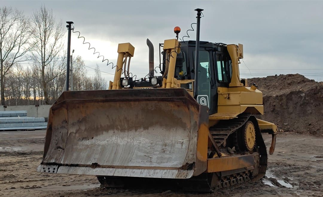
Excavator systems such as the CHCNAV MCNAV TX73 or EasyNAV EMG100 bring this capability to digging operations, allowing operators to achieve final grade without repeated checking. On grading and earthmoving equipment, solutions like the CHCNAV TD63 Pro dozer control and TG63 grader control systems enable automated or semi-automated blade control, reducing operator fatigue while improving surface consistency.
Machine control–enabled dozer performing precision grading on a construction site.
Continuous Precision Instead of Point Checks
One of the most profound changes introduced by machine control is the shift from point-based verification to continuous control. Manual methods verify grade at discrete locations. GPS machine control evaluates the entire working surface in real time.
This means over-excavation and under-cutting are identified instantly, not after the fact. Material waste decreases, haul cycles are reduced, and fuel consumption drops. More importantly, operators gain confidence to work faster because the system continuously validates their work.
For contractors, this results in fewer passes, shorter schedules, and far more predictable outcomes—especially on complex or large-scale projects.
Productivity Gains That Extend Beyond the Machine
GPS machine control improves more than machine performance; it transforms workflows. With fewer survey checks required, ground personnel exposure decreases and safety improves. Operators stay in the cab, and survey teams can focus on higher-value tasks such as design verification and as-built documentation.
When combined with GNSS surveying solutions like the CHCNAV i93 IMU-RTK or integrated base stations, contractors can build a connected digital workflow that starts with site layout and ends with final surface verification. Data flows seamlessly from design to execution, reducing miscommunication and manual data handling.
GPS vs Manual Grading Is a Management Question
The true distinction in GPS vs Manual Grading is not technological—it is managerial.
Manual grading accepts variability as inevitable. GPS machine control treats variability as a problem to be engineered out of the system. When design models guide execution directly, quality becomes repeatable and measurable. Project managers gain clearer insight into progress, cost exposure, and schedule risk.
This shift allows construction companies to scale operations more confidently. Projects become easier to staff, train, and replicate because success is less dependent on individual experience and more on standardized digital processes.
Why Machine Control Is Becoming the Industry Baseline
As infrastructure projects grow more complex and tolerances tighten, many owners and engineers now expect machine control on site. Contractors without GPS machine control face higher bidding risk, reduced competitiveness, and greater exposure to rework.
CHCNAV’s machine control ecosystem addresses this challenge by offering interoperable solutions across excavators, dozers, graders, and surveying platforms. From compact, easy-to-deploy systems to fully automated control solutions, CHCNAV enables contractors to adopt digital construction at their own pace while maintaining centimeter-level accuracy.
What was once considered advanced technology is now quickly becoming a minimum requirement for professional construction operations.
Conclusion: Certainty Is the New Competitive Advantage
The debate around GPS vs manual grading is effectively over. In an industry defined by thin margins, tight schedules, and rising safety expectations, relying solely on manual processes introduces unacceptable risk.
Machine control replaces uncertainty with control, experience with data, and rework with first-pass accuracy.
For construction companies aiming to remain competitive and scalable, GPS machine control is no longer a luxury—it is a strategic necessity.
____
About CHC Navigation
CHC Navigation (CHCNAV) develops advanced mapping, navigation, and positioning solutions designed to increase productivity and efficiency. Serving industries such as geospatial, agriculture, construction and autonomy, CHCNAV delivers innovative technologies that empower professionals and drive industry advancement. With a global presence spanning over 140 countries and a team of more than 2,000 professionals, CHC Navigation is recognized as a leader in the geospatial industry and beyond. For more information about CHC Navigation [Huace:300627.SZ], please visit: https://www.chcnav.com/about/overview
Have a question about our solutions or dealership opportunities?