CHC Navigation offers advanced GPS/GNSS machine control systems for excavators, dozers, graders, and compactors. Improve accuracy, cut costs, and complete construction projects faster with reliable global support.
Hydrographic survey demands something that most positioning technologies struggle to deliver: continuous, high-accuracy positioning in environments that actively work against it. Vessels roll and pitch in open water. Bridges and canyon walls obstruct satellite signals. Radio frequency interference in busy ports degrades GNSS fix quality. And all of this happens while a multibeam echosounder is trying to capture precise depth data below the waterline. Standalone GNSS simply cannot handle these conditions reliably. That is where GNSS-INS integration, the fusion of satellite positioning with an inertial navigation system, becomes not just useful, but essential. For modern hydrographic survey operations, a robust GNSS-INS system is the foundation everything else is built on.
Understanding GNSS and INS: the Two Systems
What Is GNSS?
GNSS (Global Navigation Satellite System) is the umbrella term for satellite-based positioning networks including GPS (United States), GLONASS (Russia), Galileo (Europe), and BeiDou (China). A GNSS receiver calculates its absolute position, velocity, and time by processing signals from multiple satellites simultaneously. In open-sky conditions, modern RTK GNSS receivers achieve centimetre-level accuracy, making them the backbone of professional surveying workflows.
The limitation is inherent to how the technology works. GNSS relies on line-of-sight radio signals between the receiver and orbiting satellites. Update rates are typically 1–10 Hz. The moment those signals are blocked, by a bridge deck, an overhanging cliff, dense urban structures, or severe weather, the positioning solution degrades or fails entirely. In hydrographic survey environments, this is not a rare edge case. It is an everyday operational reality.
What Is an IMU? INS Technology Fundamentals
An inertial measurement unit (IMU) takes a completely different approach to motion tracking. Rather than relying on external signals, it uses accelerometers and gyroscopes embedded in the sensor itself. When those accelerometer and gyroscope outputs are continuously integrated to estimate position and orientation over time, they form the basis of INS technology, or an inertial navigation system. This is the principle that lets the inertial side keep tracking motion when satellite signals are unavailable.Accelerometers measure linear acceleration along three axes; gyroscopes measure angular velocity, the rate of rotation in roll, pitch, and yaw. Together they paint a real-time picture of exactly how a vessel is moving through space, moment by moment.
The key advantage of an IMU is its update rate. Most survey-grade IMUs operate at 100–200 Hz, which is 10 to 200 times faster than a typical GNSS receiver. This high-frequency output is what makes real-time motion compensation possible for systems like multibeam echosounders, where beam geometry must stay accurate even as the vessel moves in waves.
The limitation of a standalone IMU is drift. Because it integrates acceleration and rotation over time to estimate position, small errors compound. Without periodic correction from an external reference, the position estimate wanders. Left uncorrected, even a high-quality IMU will accumulate significant position error over minutes.
Why Neither Works Alone
GNSS is precise but fragile. An IMU is continuous but drifts. These are not flaws to be worked around, they are complementary weaknesses that define why GNSS-INS integration (also called a GNSS-IMU system or GPS-INS) exists.
Consider a simple analogy. A vehicle enters a tunnel and GNSS contact is lost. A standalone GNSS system outputs nothing useful until the vehicle emerges on the other side, leaving a gap in the position record. An IMU, however, continues measuring every movement inside the tunnel, the turns, the speed changes, the gradient. It effectively "keeps driving" the navigation solution until GNSS signals return and can reset the accumulated drift. Neither system alone can achieve this. Together, they close the gap entirely.
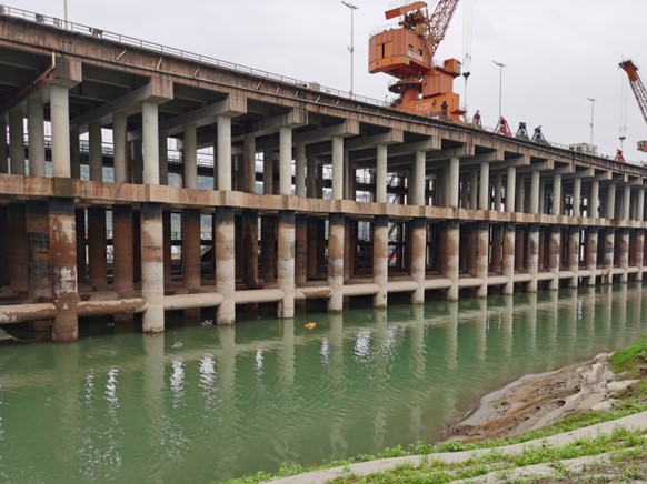
In hydrographic survey, those gaps are not theoretical. They occur under pontoon bridges on inland waterways, in river corridors hemmed in by steep terrain, and in port environments where metal structures scatter satellite signals. Every gap in the position record is a potential hole in the depth data, and a reason to repeat the survey line.
How GNSS-INS Integration Works
GNSS-INS integration, also described as sensor fusion, combines the outputs of both systems through a mathematical filtering process. In practice, this means GNSS continuously corrects and calibrates the IMU, preventing drift from accumulating. And the IMU, in turn, bridges any gaps in GNSS availability with a reliable short-term dead-reckoning solution.
The output of a GNSS-INS system is not just a position coordinate. It is a complete navigation state: position, velocity, and full three-axis attitude (roll, pitch, and heading), updated at the IMU's high rate. This fused output is what makes the system so valuable for survey applications, where attitude data is just as important as position for correcting the geometry of acoustic depth measurements.
A well-designed GNSS-INS system delivers this output continuously, in real time, even when GNSS reception is intermittent. The result is a seamless, uninterrupted navigation solution that no single-technology system can match.
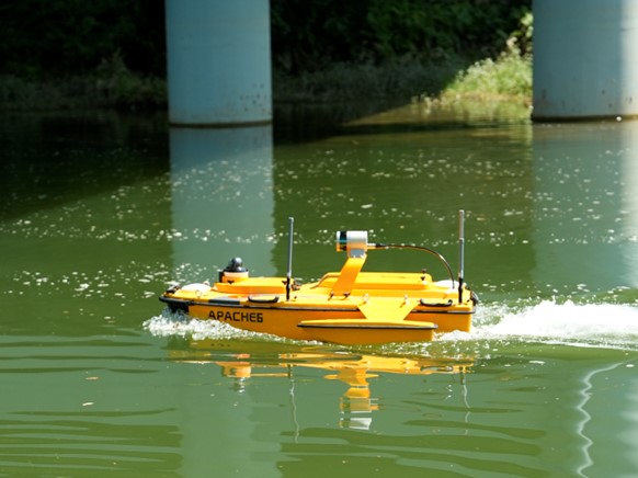
Integrated GNSS-INS navigation enables continuous, accurate positioning for USV-based hydrographic surveys, even in environments with partial satellite obstruction.
Key Benefits of GNSS-INS Integration
1. Continuous Positioning Without Signal Gaps
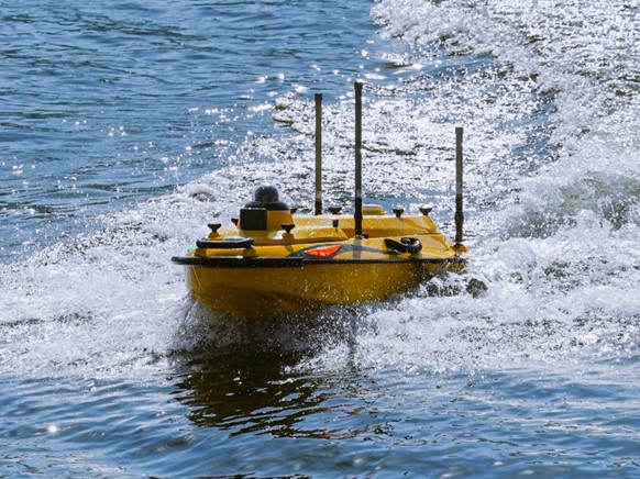
The most immediate operational benefit of GNSS-INS integration is the elimination of positioning voids. When GNSS signal drops, under a bridge, along a canyon wall, or in a congested port environment, the IMU takes over seamlessly. The navigation solution continues without interruption, and the survey vessel can maintain its trackline without breaking off or flagging data as unreliable.
For USV operators working in river corridors and sheltered coastal environments, this is a direct cost saving. Fewer data voids mean fewer re-runs. Survey missions that once required multiple passes to fill GNSS-induced gaps can be completed in a single pass, reducing field time and vessel operating hours. In remote or time-sensitive deployments, flood response surveys, for example, that efficiency gain can be critical.
2. Real-Time Motion Compensation for Accurate Depth Data
In open water, a survey vessel is never truly still. Every wave introduces roll, pitch, and heave. For a multibeam echosounder, this movement is a source of systematic error. If the sonar transducer tilts even slightly as a swath of acoustic beams is transmitted, the geometry of the depth measurements is corrupted. The sea floor appears rougher than it is. Point clouds shift laterally. Features are smeared.
Motion compensation corrects this in real time. The IMU's 100–200 Hz roll, pitch, and yaw measurements are fed directly into the echosounder's processing pipeline, adjusting each beam's geometry for the vessel's instantaneous attitude at the moment of transmission and reception. The result is depth data that accurately reflects the sea floor, not the state of the sea surface above it.
The HQ-400 multibeam echosounder takes this a step further with a factory-pre-calibrated IMU built directly into the sensor unit. Roll, pitch, and yaw compensation is applied at the sensor level, requiring no separate heading/attitude peripheral. For survey operations in poor GNSS environments, the HQ-400 also supports PPK (Post-Processed Kinematic) workflows, allowing accurate position solutions to be computed after the fact from logged raw GNSS data.
3. Precise Repeat-Line Navigation
Many survey applications require a vessel to return to exactly the same tracklines across multiple deployment sessions. Dredging progress monitoring compares before-and-after surveys to quantify material removed. Sediment transport studies track bathymetric change over weeks or months. Infrastructure inspection surveys must cover the same corridor each time to detect change reliably.
All of these workflows depend on accurate, stable heading, and this is where GNSS-INS integration matters beyond just position. A fused GNSS-IMU solution provides a heading estimate that is both accurate and smooth, free of the erratic jumps that can occur when a standalone GNSS antenna loses and regains lock. Consistent heading feeds directly into the survey vessel's navigation controller, helping it maintain or return to precise tracklines even in turbulent or flowing water.
The APACHE 4 and APACHE 4 Pro USVs both integrate GNSS and IMU with an advanced navigation controller specifically designed to maintain position and heading stability in challenging conditions, including turbulent river flow. Without that stable heading, survey lines drift, and drifting survey lines mean wasted re-runs and compromised change-detection analysis.
4. Reliable Performance in Challenging Environments
Ports, harbours, inland waterways, and shallow coastal zones share a common challenge: the infrastructure that defines them also degrades GNSS performance. Cranes, loading gantries, bridge piers, and embankment walls all contribute to multipath interference, satellite signals that arrive at the GNSS antenna after bouncing off nearby surfaces, introducing position errors. In some port basins, direct satellite visibility is limited to a narrow window of sky.
A GNSS-INS system maintains solution quality under these conditions. Even when only a few satellites are visible and multipath is severe, the IMU's inertial solution supports the GNSS through brief degraded periods, averaging out spurious position jumps and maintaining heading continuity. The fused output remains usable in environments where a standalone GNSS receiver would produce unreliable, jumpy coordinates.
The APACHE 4 Pro adds an anti-entanglement design specifically for deployment in aquatic vegetation environments, shallow, weed-choked waterways such as lake margins and wetland corridors where survey coverage is difficult with conventional hull designs. Combined with GNSS-INS navigation, it extends reliable survey capability into environments that would be impractical to survey otherwise.
5. Streamlined Workflow and Reduced Post-Processing
An integrated GNSS-INS solution does more than improve data quality in the field, it simplifies the entire survey workflow from acquisition through to final deliverable. Because the system outputs a fused, time-stamped navigation state at high frequency, the raw data arriving at post-processing software is already geometrically corrected and temporally consistent. Less manual intervention is required to clean, align, and validate the dataset.
The HQ-400 exemplifies this integrated approach. Sonar, water temperature, attitude, positioning, and heading sensors are all housed in a single 2.7 kg unit with built-in noise filtering and optimised processing. Rather than assembling a multi-box sensor stack from different vendors, each requiring its own calibration, cabling, and data synchronisation, operators deploy a single compact device. Cleaner raw data, fewer integration variables, and a faster path from field acquisition to final output translate directly to lower total project cost.
GNSS-INS Integration in Action: A Complete Hydrographic Survey System
Understanding the benefits of GNSS-INS integration is one thing. Seeing how those benefits stack up across a complete, layered survey system is another. CHCNAV's complete hydrographic survey solution demonstrates how each component contributes to overall data quality and operational efficiency.
Both the APACHE 4 and APACHE 4 Pro USVs integrate GNSS and IMU with an advanced autopilot navigation controller, providing the stable, accurate, and repeatable positioning foundation that every survey layer depends on.
The APACHE 4 weighs 13 kg, is designed for single-operator deployment, and handles a wide range of survey missions: flood risk assessment, sediment transport studies, port current analysis, and river discharge measurement. Its compact form makes it practical for rapid deployment from riverbanks or small boat ramps.
The APACHE 4 Pro extends this foundation with a larger payload capacity, higher bathymetric resolution capability, and the anti-entanglement design that makes it suitable for vegetated waterways. Its expanded use case list includes water resource survey, hydrological survey, and emergency rescue response, scenarios where survey accuracy and vessel reliability must be maintained even in difficult, unpredictable conditions.
Layer 2, Multibeam Data Quality: HQ-400
Mounted to the APACHE 4 or APACHE 4 Pro (or any compatible survey platform), the HQ-400 is where GNSS-INS integration translates directly into bathymetry survey data quality. Its pre-calibrated IMU applies roll, pitch, and yaw compensation at the sensor itself, no external motion reference unit required. The result is geometrically accurate depth data regardless of vessel motion.
At 2.7 kg, the HQ-400 is compact enough for lightweight USV platforms without compromising payload capacity or vessel stability. Its integrated design reduces setup time significantly compared to multi-component sensor stacks, and its PPK-capable positioning ensures reliable data quality even in environments with intermittent GNSS coverage.
Typical applications include river and lake topography, tailings pond survey, port terminal survey, and channel dredging monitoring, anywhere that precise, repeatable depth data is required in environments that challenge conventional survey methods.
The RS3600D is a dual-frequency ADCP (Acoustic Doppler Current Profiler) that adds water current and discharge measurement to the survey system. Operating at both 1200 kHz and 3600 kHz, it profiles water velocity from surface to bed with accuracy of 0.25% ± 2 mm/s and a resolution of 1 mm/s.
Critically, the RS3600D's current data is position-tagged using the GNSS-INS navigation solution from the host USV. Accurate position assignment for each velocity profile requires the same continuous, drift-corrected positioning that underpins the bathymetry workflow. GNSS-INS integration makes this possible even in the sheltered river environments where ADCP measurements are most often needed.
Use cases include hydrological measurement for flood modelling, ecological flow monitoring, and channel monitoring for water resource management, applications where both depth and current data are required from the same platform in a single deployment.
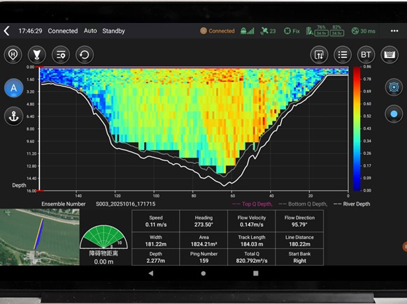
A complete GNSS-INS-equipped hydrographic survey system delivers clean bathymetric data through real-time motion compensation and continuous positioning.
Conclusion: Why GNSS-INS Integration Is Foundational
GNSS-INS integration solves the core challenge of marine and hydrographic surveying: delivering continuous, accurate, motion-compensated positioning in environments that would defeat either technology alone. Signal gaps that once created data voids are bridged. Wave motion that would corrupt depth measurements is compensated. Survey lines that would drift without stable heading hold their course. Data that would require extensive post-processing correction arrives clean.
Whether the requirement is stable USV navigation on a turbulent inland waterway, clean multibeam data from a compact echosounder, or full hydrological profiling combining depth and current measurement, GNSS-INS integration is the technology that makes it reliable and repeatable. It is not an optional enhancement, it is the foundation on which accurate hydrographic survey is built.
____
About CHC Navigation
CHC Navigation (CHCNAV) develops advanced mapping, navigation and positioning solutions designed to increase productivity and efficiency. Serving industries such as geospatial, agriculture, construction and autonomy, CHCNAV delivers innovative technologies that empower professionals and drive industry advancement. With a global presence spanning over 140 countries and a team of more than 2,000 professionals, CHC Navigation is recognised as a leader in the geospatial industry and beyond. For more information, visit www.chcnav.com.
Explore CHC Navigation's USV hydrographic solutions for precise bathymetric surveys, environmental monitoring, and underwater construction - powered by Apache USV platforms and advanced sonar sensors.