CHC Navigation offers advanced GPS/GNSS machine control systems for excavators, dozers, graders, and compactors. Improve accuracy, cut costs, and complete construction projects faster with reliable global support.
GPS Machine Control for Excavators: Choosing the Right Approach for Your Projects
2026-03-23
Tighter project schedules, rising material costs, and ongoing labor shortages have made traditional excavation methods increasingly difficult to sustain. GPS machine control has moved from a specialty tool to an operational standard, not because the technology is new, but because the cost of working without it keeps climbing.
The key question for contractors today is not whether to adopt machine control, but which approach fits how your team actually works on site.
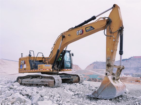
A CAT excavator using GPS machine control on a construction site, with the TX73 display showing cut and fill guidance.
What GPS Machine Control Actually Solves
Most excavation inefficiencies trace back to three recurring problems:
Over-excavation. Every pass below design grade adds backfill, compaction, material cost, and time. GPS machine control guides the bucket precisely to the target surface, helping operators get it right the first time.
Grade-checker dependency. Traditional workflows require surveyors or grade checkers working near active machines, slowing production and creating safety exposure. Real-time cab guidance reduces the need for ground personnel.
Operator variability. Skill gaps between operators translate directly into inconsistent results. Machine control gives every operator clear, visual grade guidance relative to the design, narrowing the gap between experienced and mid-level crews.
The result: excavation moves from trial-and-check to controlled, repeatable execution, with measurable impact on cost, schedule, and site safety.
The Technology Behind the Guidance
Modern GPS machine control systems rely on two integrated technologies working in parallel to deliver accurate, real-time guidance in the cab.
Positioning Accuracy Through GNSS and IMU Fusion
GNSS satellites provide the machine's absolute position on the ground. An onboard inertial measurement unit (IMU) continuously tracks pitch, roll, and heading, compensating for machine movement, vibration, and uneven terrain. Together, they maintain a stable and accurate spatial reference at all times, even on active, dynamic job sites where conditions change constantly.
Real-Time Kinematics for Bucket Awareness
Sensors mounted on the boom, stick, and bucket calculate the precise location of the bucket teeth relative to the design surface, moment to moment. RTK positioning delivers centimeter-level accuracy, giving operators a live picture of exactly where the bucket is in relation to grade. This continuous awareness is what eliminates guesswork and enables accurate excavation on the first pass.
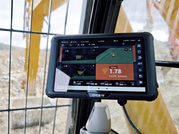
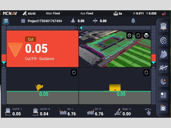
The CHCNAV machine control cab display overlays the design surface in 3D, showing cut/fill depth and slope guidance in real time.
Two Workflows, Two Types of Machine Control
Excavation projects don't follow a single pattern. The way work is planned and executed on site varies significantly, and machine control needs to reflect that reality.
Data-Centric: Built for Model-Driven Projects
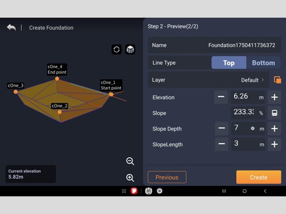
On infrastructure and civil engineering projects, excavation is driven by digital models prepared before machines arrive. These environments require machine control that can import complex design files, display 3D surfaces clearly in the cab, and stay synchronized with design revisions as the project evolves.
Data-centric systems support industry-standard formats (LandXML, DWG, DXF), handle complex machine configurations including tiltrotators and swing booms, and connect to cloud-based workflows for real-time design updates between office and field.
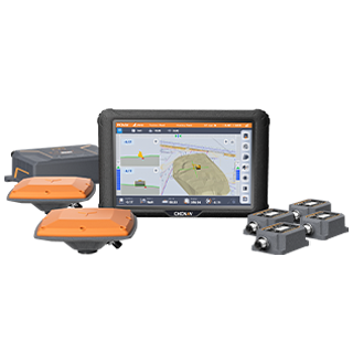
CHCNAV MCNAV TX73: Designed for model-driven excavation on highways, large foundations, and complex grading projects. The TX73 supports high-resolution 3D surface visualization, cloud-based design synchronization, and complex machine configurations, keeping operators fully aligned with the latest approved design throughout the project. Its advanced GNSS and IMU sensors deliver precise bucket tip positioning, enabling efficient, accurate digging for all types of construction projects, from large-scale infrastructure to highly detailed site work.
Field-Centric: Built for Autonomy and Speed
Not every job starts with a 3D model. Utility installation, drainage, agricultural earthmoving, and smaller construction projects often rely on 2D drawings, reference elevations, or operator judgment. For these workflows, speed and simplicity matter most, not deep data integration.
Field-centric machine control lets operators define slopes, reference lines, and working surfaces directly using the bucket as a reference, with no design files required. Setup is fast, training is short, and excavation can start immediately.
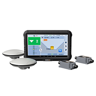
CHCNAV EasyNAV EMG100: Built for field-driven projects where responsiveness and operator autonomy drive productivity. The EMG100 allows operators to define reference surfaces directly on site without design files or survey support, making it ideal for utilities, landscaping, drainage, and other small-scale construction projects. With centimeter-level accuracy and quick setup, it reduces reliance on surveyors and maximizes efficiency in projects where speed and flexibility are critical.
Choosing the Right Excavator Machine Control Solution
The right system depends on your project types, workflow, and team. Use these three decision points as a guide:
Project complexity. Model-driven projects with design files and frequent updates are best served by data-centric systems like the MCNAV TX73. For field-defined work where speed and simplicity matter most, field-centric systems like the EasyNAV EMG100 are the more practical fit.
Fleet composition. Contractors running mixed project types may benefit from both approaches, matched to each machine's role on site.
Positioning reliability. Regardless of system type, consistent RTK accuracy and stable in-cab feedback are non-negotiable. A system that underperforms in real site conditions creates more problems than it solves.
Business Impact: ROI Beyond Technology
The return on GPS machine control extends well beyond positioning accuracy. The gains are measurable across cost, labor, and project delivery:
Reduced over-excavation cuts material, hauling, and compaction costs directly tied to rework
Lower grade-checker dependency reduces labor costs and removes ground personnel from the immediate machine work zone, improving site safety
Consistent production rates across operator experience levels, since cab guidance narrows the gap between skilled and mid-level operators
More predictable project timelines and stronger client relationships as a result of fewer delays and less remedial work
In an industry facing tighter margins and ongoing labor constraints, these gains accumulate quickly. For most contractors, the investment pays back within the first few projects.
____
About CHC Navigation
CHC Navigation (CHCNAV) develops advanced mapping, navigation, and positioning solutions designed to increase productivity and efficiency. Serving industries such as geospatial, agriculture, construction and autonomy, CHCNAV delivers innovative technologies that empower professionals and drive industry advancement. With a global presence spanning over 140 countries and a team of more than 2,200 professionals, CHC Navigation is recognized as a leader in the geospatial industry and beyond. For more information about CHC Navigation [Huace:300627.SZ], please visit: https://www.chcnav.com/about/overview